Land Cover Classification
|
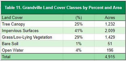
Grandville’s tree canopy is estimated at 25% (Table 11), which is on the lower end of the reference Michigan communities. Impervious surfaces (buildings and roads) make up 41% of the land cover. Grass and low-lying vegetation comprises 29% of the community. The city's border, particularly to the north by the river, have the greatest canopy cover, while the areas along the major neighborhoods, industrial areas, and shopping centers have the greatest amount of impervious surfaces (Figure 7).
|
|
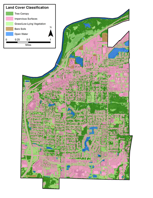
Figure 7. Grandville Land Cover Classification
To view this and other maps in an interactive format visit the Story Map
Tree Canopy Related to Land Use
Tree canopy levels tend to correlate with land use types. Figure 8 illustrates a land use map of Grandville. Table 12 presents land uses as they relate to land cover types detailed in the previous section.
In a typical community, commercial areas tend to have lower levels of tree canopy and higher levels of impervious surfaces than residential districts. This is true in Grandville, where the commercial areas have 13% tree canopy and 59% impervious surfaces, while residential areas have 26% tree canopy and 37% impervious surfaces. The agriculture/forested lands in Grandville have the highest level of tree canopy, 61%, and lowest level of impervious surface 5%; and institutional lands have the lowest canopy cover at 5% and highest impervious surface at 64%.
Opportunities should be pursued to increase canopy cover in commercial and institutional areas due to low canopy cover and high amounts of impervious surface. Comparing these two factors could indicate that these land uses may have outsized impacts on the quantity and quality of stormwater runoff. Planting opportunities might be additionally limited in institutional areas due to the small footprint of this land use (1% of the city acreage).
Open space/recreational, contains the highest percentage of grass and low-lying vegetation (60%), which could provide an opportunity to increase canopy cover. Across the other land classes, grass/low-lying vegetation makes up at least 25% of the land cover. Overall, these results indicate that there are planting opportunities across land use classes, however these might be limited in some cases by impervious surfaces.
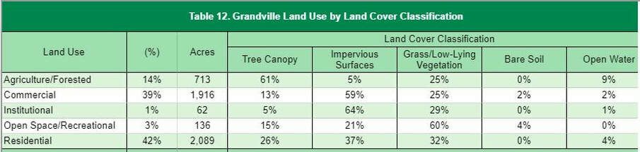
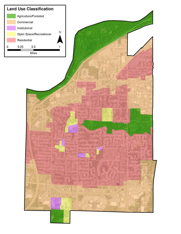
Figure 8. Grandville Land Use Classification
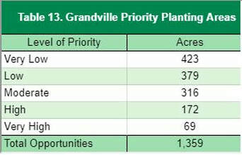
Priority Planting Areas
|
The planting priority levels map (Figure 9) can be used to focus in on the locations in which plantings may deliver the highest impacts in terms of ecosystem benefits and overall benefits to the community. Grandville can use this as a guideline for deciding where future trees can be planted to have the greatest impact on benefits and stormwater runoff. Of the 1,359 plantable acres, 40% of those acres (557 acres) are listed as a planting priority of moderate or above. If only these areas are planted, Grandville’s canopy would increase from 1,232 acres to 1,789 acres, increasing the total canopy cover to 36%.
|
|
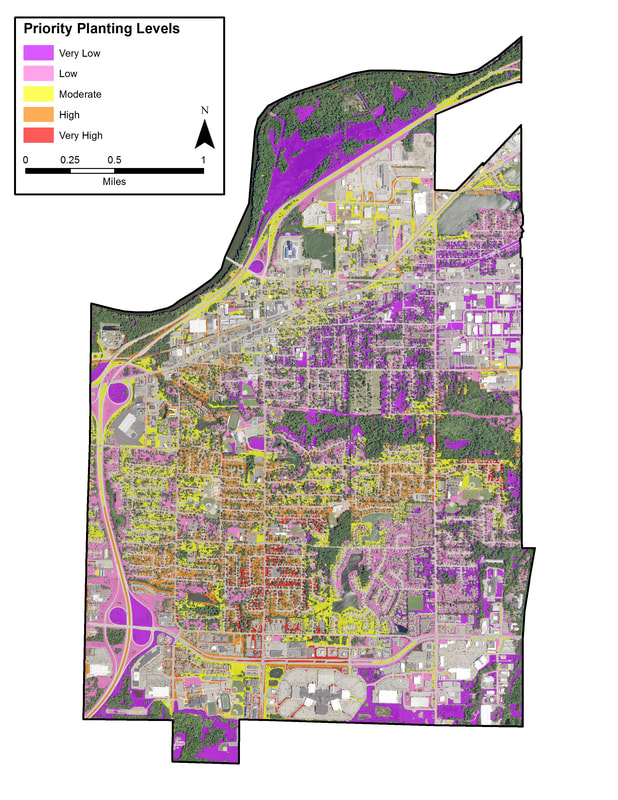
Figure 9. Grandville prioritized planting areas.
Tree canopy percent by census block analysis found below can be used as a supplemental tool to determine which neighborhoods are in most need of planting (Figure 10). For Grandville, the tree canopy percent analysis largely confirms the results of the planting priority analysis, which shows small pocketed areas of Moderate and higher planting priorities dotted throughout the central residential and commercial areas in conjunction with lower levels of canopy.
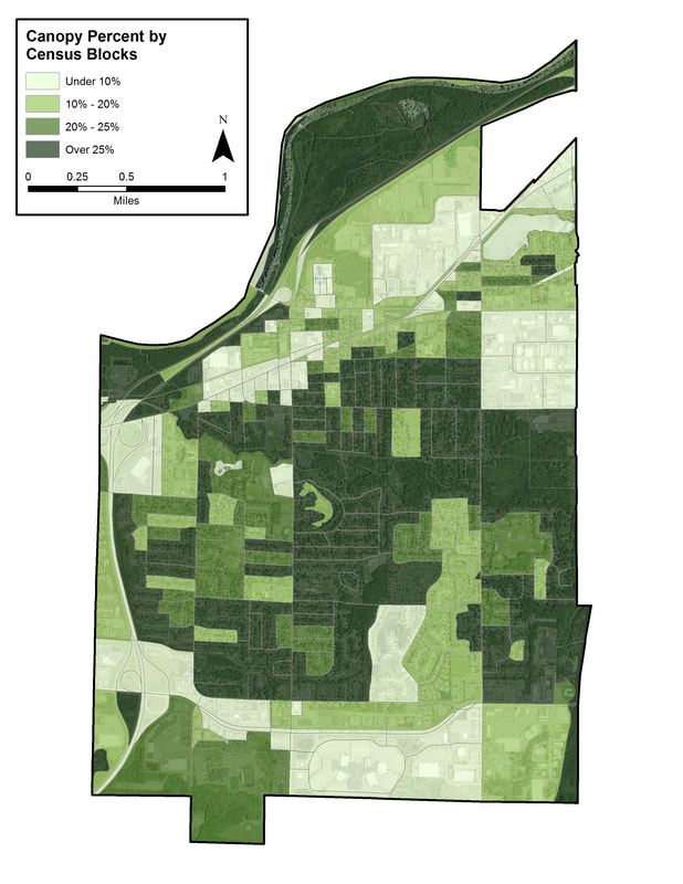
Figure 10. Grandville tree canopy by census block.
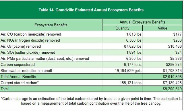
Ecosystem Benefits Analysis
Community forests are important components of the ecosystem and provide quantifiable benefits. Grandville realizes an annual benefit of $2,010,895 for reductions in air pollution, stormwater reduction, and carbon sequestration from the tree canopy. The city also benefits from carbon stored in the trees, which contributes $7,189,425 over their lifetime.
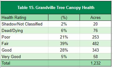
Custom Analysis: Urban Tree Canopy Health Assessment
|
By analyzing the spectral characteristics of the tree canopy layer, the Normalized Difference Vegetation Index (NDVI) was used as an indicator to assess vegetation health by analyzing the visible and near infra-red bands. Using remote sensing method, locations of poor vegetation health was quantified and further assessed to determine possible dead or dying trees. Grandville’s 1,232 acres of tree canopy were analyzed for health assessment.
|
|
Based on this analysis, approximately 72% of the acres are in fair or greater health (Table 15). 27% were in poor or worse condition. 2% was considered shadow or otherwise not classified. The majority of Grandville’s canopy was rated to be in Fair condition (39%).
These results could be used to target maintenance, restoration, or removal efforts to improve deficient areas of the urban canopy. Figure 11, the map of tree health index, provides a visual indicator of some of these areas. Higher health rating canopy can be seen in the northern part of town by the river, and poorer quality dotted throughout the main residential and commercial areas.
These results could be used to target maintenance, restoration, or removal efforts to improve deficient areas of the urban canopy. Figure 11, the map of tree health index, provides a visual indicator of some of these areas. Higher health rating canopy can be seen in the northern part of town by the river, and poorer quality dotted throughout the main residential and commercial areas.
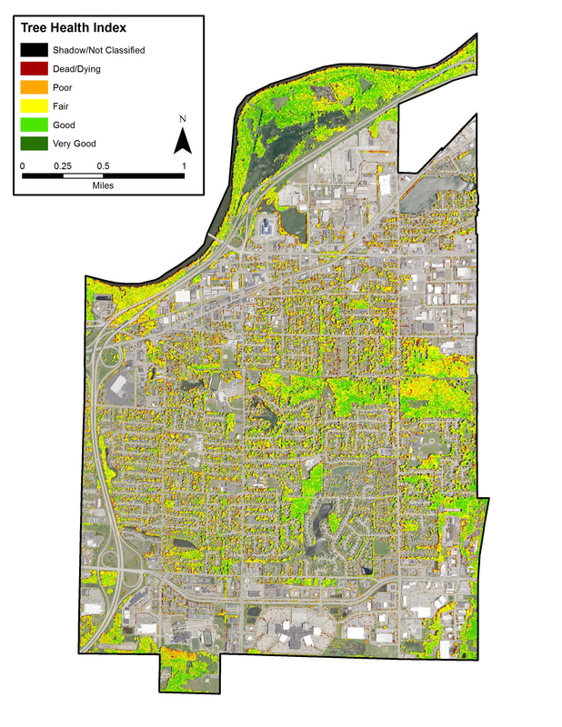
Figure 11. Grandville tree health index.
