Land Cover Classification
|
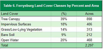
Ferrysburg’s tree canopy is estimated at 39% (Table 6), which compares favorably with other Michigan communities. Impervious surfaces (buildings and roads) make up 18% of the land cover. Grass and low-lying vegetation comprises 26% of the community. The borders of Ferrysburg, particularly on the far west and east sides of the city, have the greatest canopy cover, while the areas along the main downtown streets near the river have the greatest amount of impervious surfaces (Figure 2).
|
|
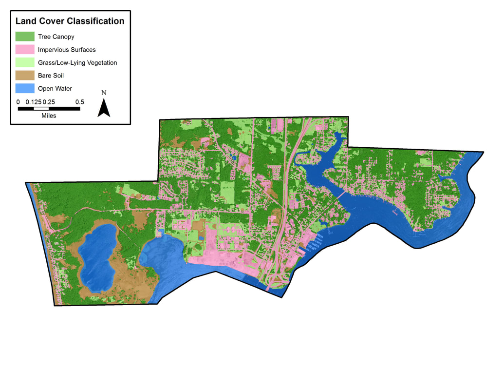
Figure 2. Land Cover Classification
To view this and other maps in an interactive format visit the Story Map
To view this and other maps in an interactive format visit the Story Map
Tree Canopy Related to Land Use
Tree canopy levels tend to correlate with land use types. Figure 3 illustrates a land use map of Ferrysburg. Table 7 presents land uses as they relate to land cover types detailed in the previous section.
In a typical community, commercial areas tend to have lower levels of tree canopy and higher levels of impervious surfaces than residential districts. This is true in Ferrysburg where residential and agriculture/forested land account for much of the land use and contain the highest levels of tree canopy, 48% and 85%, respectively. While commercial and open space/recreational areas contain the lowest percentage of tree canopy in the city, 5% in open space/recreational areas and 15% in commercial areas.
While opportunities should be pursued to increase canopy cover in commercial and open space/recreation areas, suitable planting locations may be limited by high levels of impervious surfaces and open water. Commercial areas have the highest levels of impervious surfaces (55%); while open space/recreational areas, which includes the bay, river, and several other bodies of water, contains the highest percentage of open water (71%). Careful review of these areas, to identify suitable planting locations and increase tree canopy is critical because these land uses may have the most significant impact on the quantity and quality of the community’s stormwwater run-off. Institutional areas, which account for ~1% of the city’s overall acreage, have 27% grass/low-lying vegetation and 26% bare soil. Based on this land cover, there may be some suitable space for expanding tree canopy within this land use.
Overall, the results of this analysis indicate that there are planting opportunities across all the land use classes, however these may be limited by impervious surfaces or open water.
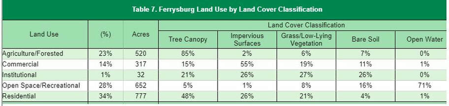
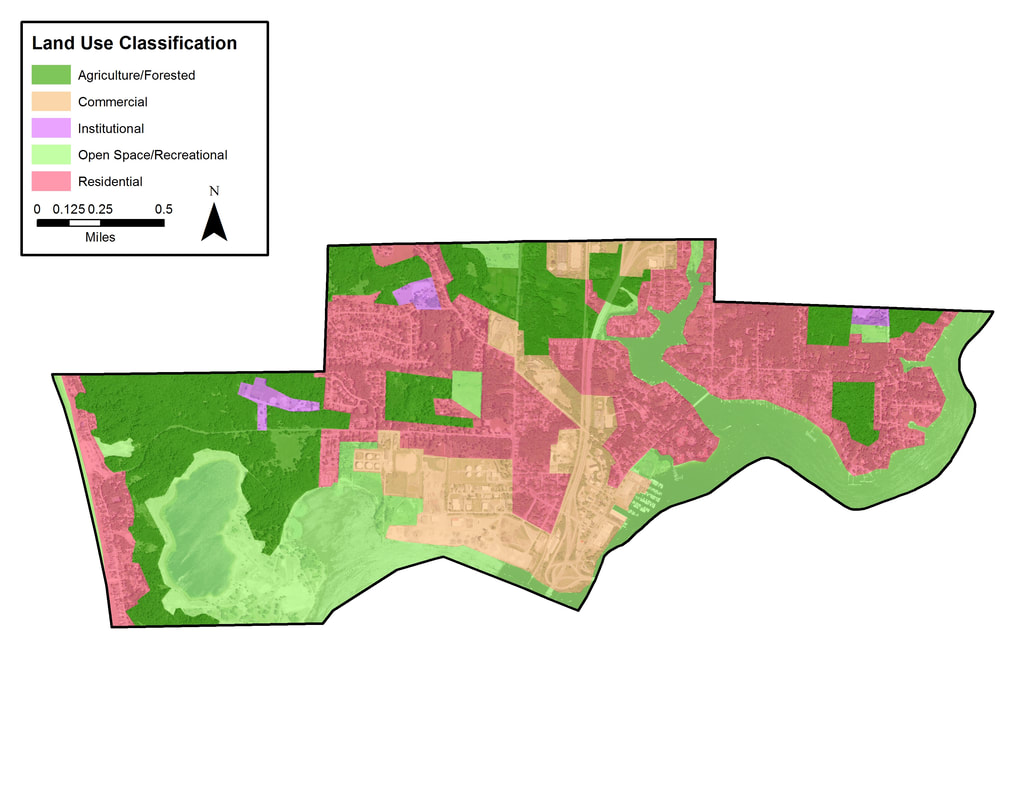
Figure 3. Ferrysburg land use classification
Priority Planting Areas
|
The planting priority levels map (Figure 4) can be used to focus on the locations in which plantings may deliver the highest impacts in terms of ecosystem benefits and overall benefits to the community. Ferryburg can use this as a guideline for deciding where future trees can be planted to have the greatest impact on benefits and stormwater runoff. Of the 538 plantable acres, 12% of those acres (65 acres) are listed as a planting priority of Moderate or above. If only these areas are planted, Ferrysburg’s canopy would increase from 514 acres to 579 acres, increasing the total canopy cover to 37%. In many cases the lower levels of priority can be attributed to the land use type. In Ferrysburg’s case this is due in part to the location and levels of agricultural and forested land. More information on the inputs for the planting analysis can be found on the Project Overview.
|
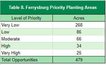
|
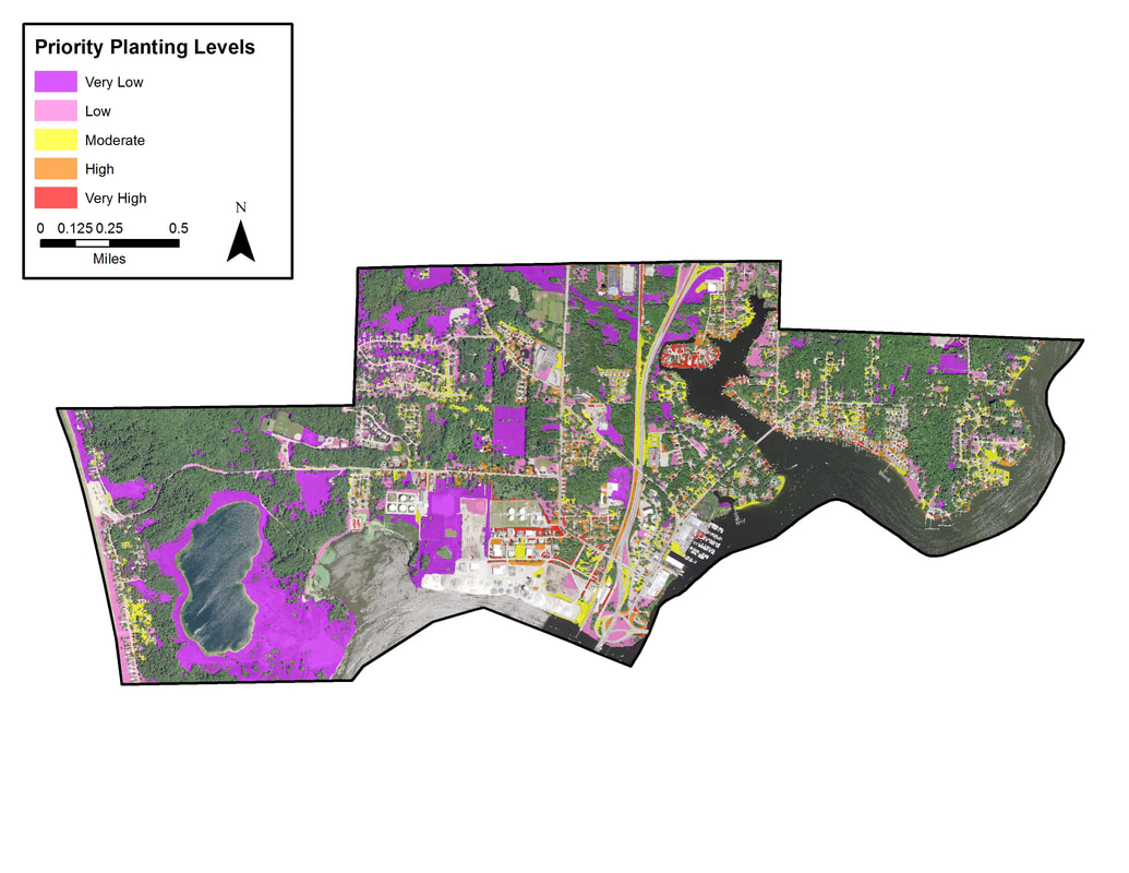
Figure 4. Ferrysburg prioritized planting areas.
Tree canopy percent by census block analysis found below can be used as a supplemental tool to determine which neighborhoods are in most need of planting (Figure 5). For Ferrysburg, the tree canopy percent analysis largely confirms the results of the planting priority analysis, which shows small pocketed areas of Moderate and higher planting priorities distributed throughout the downtown area.
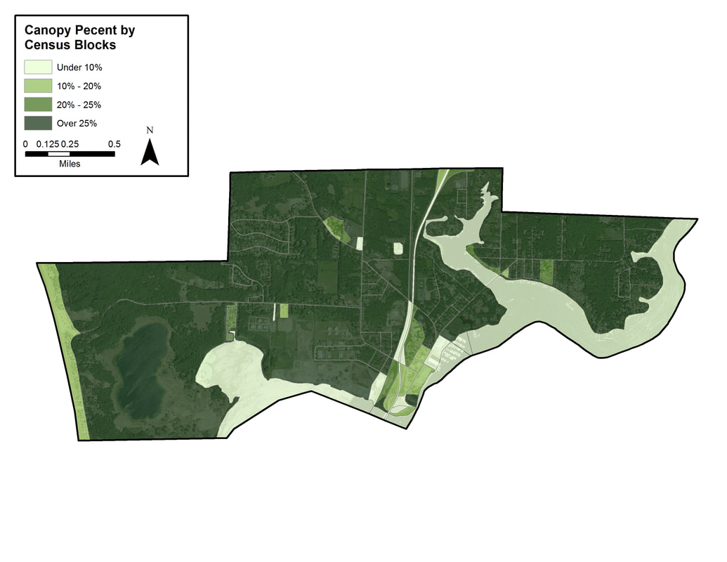
Figure 5. Ferrysburg tree canopy by census block.
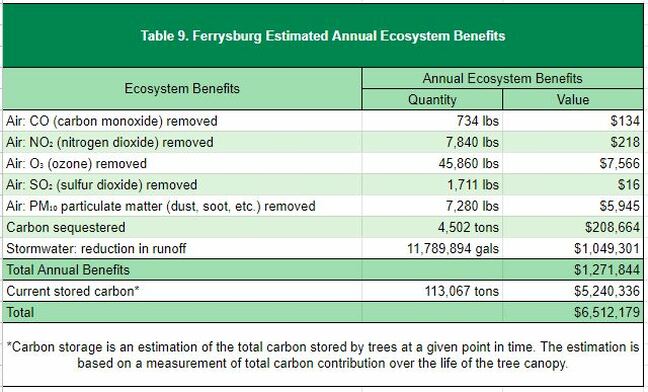
Ecosystem Benefits Analysis
Community forests are important components of the ecosystem and provide quantifiable benefits. Ferrysburg realizes an annual benefit of $1,271,844 for reductions in air pollution, stormwater reduction, and carbon sequestration from the tree canopy. The city also benefits from carbon stored in the trees, which contributes $5,240,336 over their lifetime.
Custom Analysis: Urban Tree Canopy Health Assessment
By analyzing the spectral characteristics of the tree canopy layer, the Normalized Difference Vegetation Index (NDVI) was used as an indicator to assess vegetation health by analyzing the visible and near infra-red bands. Using remote sensing method, locations of poor vegetation health was quantified and assessed to determine possible dead or dying trees. Ferrysburg’s 898 acres of tree canopy were analyzed for health assessment.
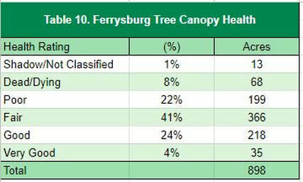
Based on this analysis, approximately 69% of the acres are in fair or greater health (Table 10). 30% were in poor or worse condition. 1% was considered shadow or otherwise not classified. The majority of Ferrysburg’s canopy was rated to be in Fair condition (41%).
These results could be used to target maintenance, preservation, restoration, or removal efforts to improve deficient areas of the urban canopy. Figure 6, the map of tree health index, provides a visual indicator of some of these areas. Sections of poor condition trees can be seen near the north central part of town and pocketed throughout the community. The canopy east of Smith Bayou has, in general, the highest quality canopy in the city.
These results could be used to target maintenance, preservation, restoration, or removal efforts to improve deficient areas of the urban canopy. Figure 6, the map of tree health index, provides a visual indicator of some of these areas. Sections of poor condition trees can be seen near the north central part of town and pocketed throughout the community. The canopy east of Smith Bayou has, in general, the highest quality canopy in the city.
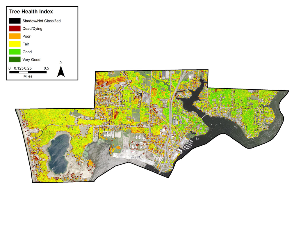
Figure 6. Ferrysburg tree health index.
